
Denver International Airport (DEN) ranks as one of the biggest US airports in terms of land coverage, having 33,000+ acres spread over an area northeast of Denver, Colorado. Given its vastness, being aware of the Denver airport map will definitely come in handy in saving you time when visiting the place.
From connections to rental cars to getting to your gate at the Denver airport, understanding the Denver airport map will make a world of difference to your experience when visiting. In the following sections of the Denver airport map, we will go through the different sections of the airport, how to navigate from one section to another, as well as how to make the most of the Denver airport map regardless of whether you are visiting for the first or the hundredth time.
DEN Airport Layout Description
The DEN Airport utilizes a single main terminal named Jeppesen Terminal, connecting three different concourses: A, B, and C. As compared to other airports, which comprise of multiple individual terminals, the DEN airport layout comprises of only a single main terminal. Thus, passengers need to use the main terminal before heading to their respective concourses through either the train or walkway.
The Jeppesen Terminal includes the areas of check-in counters, security screening points, baggage collection, ground transportation, as well as many shops and restaurants. The travelers who are there move to Concourses A, B, and C via the Automated Guideway Transit (AGT), also known as the airport train.
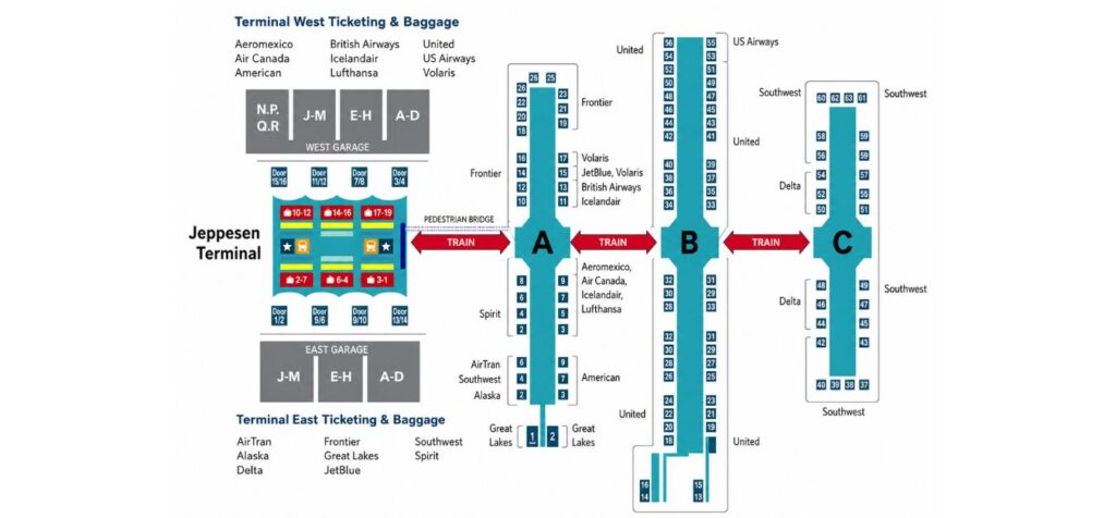
How to Understand the Three Concourses
Concourse A is located closest to the Jeppesen Terminal and may be accessed either by train or a picturesque outdoor walkway. Concourse A is home to the domestic and some international flights, including those of Southwest Airlines and several other airlines that fly to Canada, Mexico, and elsewhere.
Concourse B is the biggest one of the three and serves as the main concourse of United Airlines, which dominates in DEN. Being larger, Concourse B also has the biggest number of gates and passengers, therefore.
Concourse C, however, mainly accommodates domestic airlines like Frontier Airlines and regional airlines. Generally, this terminal is less crowded than Concourse B and has an average selection of services and amenities.
All three concourses are designed as linear terminals where the gates are numbered consecutively. Hence, with the knowledge of your gate number, you can easily navigate around these terminals. In addition, there are digital displays and paper maps of the concourses and terminals to assist travelers in orienting themselves.
DEN Airport Map Interpretation
While reading the official Denver International Airport (DEN) map, it is essential to identify the following zones of the facility:
- Level 5 (Jeppesen Terminal): Ticketing, check-in counters, and security checkpoints
- Level 4: Mezzanine level with additional dining and shopping
- Level 3: Baggage claim and ground transportation
- Level 1: Commuter rail station and rental car facilities
- Concourse Levels: Gates, dining and shopping areas
The colored signs indicate the concourse you should take to get to the gates. Each concourse has a specific color on the DEN airport map.
Getting Between Concourses: The Airport Train
Taking the AGT train is the quickest and easiest way of traveling between the Jeppesen Terminal and Concourses A, B, and C. Trains operate often, usually about twice per minute, and the entire circle ride takes just a few minutes. Announcements overhead and displays on the platform tell where the train is going, so be sure to confirm before boarding in case of a tight connection.
Alternatively, for those preferring to walk, access to Concourse A is available via an outside bridge from the Jeppesen Terminal, which gives a view of the airport’s characteristic peaked roof structure. Access to Concourses B and C can be by train or by walking through tunnels if such access is open; however, it is important to confirm the current walkway accessibility through signs at the airport, as it may not always be available depending on ongoing construction or renovation works.
Parking and Ground Transportation at DEN Map
Parking is one of the options provided by the DEN and is easily found on the airport map:
- Terminal parking garages (East and West): Closest to Jeppesen Terminal, suitable for quick trips
- Economy lots: Slightly further away with a shuttle service, offering cheaper daily rates
- Off-site and third-party lots: Situated along Peña Boulevard with a shuttle pick-up
Ground transport options include rideshare, taxi and car rentals at Level 3 (Jeppesen Terminal) and the Westin Hotel/Transit Center, where there is also a connection to the University of Colorado A Line commuter rail going straight to Union Station in downtown Denver.
Amenities & Tips for Navigating the Airport
Each concourse features restaurants, stores, charging stations, as well as places to sit down and rest; Concourse B usually boasts the largest variety because of its size and number of visitors. Free Wi-Fi is provided all around the airport, and there are also digital kiosks with interactive guides installed in the terminal and concourses that will help travelers find their way to the gate, bathrooms, food venues, and other services.
If you have a connection at DEN, make sure you look for the train platforms that are related to your concourse and gate according to your boarding pass. Being a connecting airport, extra buffer time must be considered when flying in and out of DEN airport, especially during high seasons and when there might be snowfall in Denver.
Conclusion
Knowledge of the DEN airport map beforehand will help you determine the walking distance, estimate your connection time, and find the necessary facilities such as currency exchange, pet relief, and assistance for accessibility. As DEN is quite large from a geographical standpoint in comparison to many other airports in the USA, first-time travelers can easily miscalculate the time required to reach parking areas, the terminal, and boarding gates. The DEN airport map beforehand will save you from extra stress.
Questions Related to the DEN Airport Map
There is only one terminal at Denver International Airport, and it is called the Jeppesen Terminal. It includes three concourses, A, B, and C, and is connected by the underground train service. In contrast to airports that have multiple terminals, all passengers go through the single terminal in order to check in and pass security.
After you pass the security checkpoint in the Jeppesen Terminal, you will then board the Automated Guideway Transit (AGT) train to arrive at Concourse A, B, or C. The trains run regularly and have signs indicating what concourse they are bound for. There is also the option of going to Concourse A by way of an outdoor bridge.
United Airlines operates out of Concourse B, which is DEN’s largest concourse. Southwest Airlines and various international airlines operate out of Concourse A. Frontier Airlines and other domestic airlines operate out of Concourse C. You need to check your boarding pass to know which concourse you will be using.
It takes 15-20 minutes to change concourses at DEN. This is based on travel by train to your gate and waiting time. During peak hours and when you have bags to check in or have further security clearance, it would be prudent to allocate 30 minutes or more.
The official and current map of Denver International Airport can be accessed through its official website and also via the DEN app. Physical maps and digital navigational stations are available throughout the Jeppesen Terminal and each concourse.